According to Wikipedia, Guillaume Le Vasseur de Beauplan (c. 1600 – 1673) was a French-Polish cartographer, engineer and architect. Beauplan served as artillery captain for the army of the Crown of the Kingdom of Poland between 1630 and 1647 or 1648. He was sent to Ukraine where he served under Stanisław Koniecpolski in 1637–1638. He used his architectural skills while in the military. In 1639, he was involved in the rebuilding of the Kodak Fortress. He also built a fortress at Bar, worked on Brody Castle, and structures in Kremenchuk.
In 1639, Beauplan created the first “descriptive” map of Ukraine. He created a map of Ukraine in 1648 that had detailed border information. By 1654 he was working in Danzig. He created a map with a scale of 1:452,000 and an additional map scaled at 1:1,800,000. Both maps were engraved by Willem Hondius. These maps would go on to be published in Rouen, France and reproduced by Veniiamyn Kordt. Beauplan published another map of the Dnieper River in 1662.
University of Chicago: “De Beauplan was the first scholar of the post-Renaissance Europe to regard Ukraine as an independent geographical and political unit, which possessed its own individual, natural, economic, and cultural characteristics. His outstanding Description d’Ukraine may be called the first Ukrainian geography. His maps of Ukraine were models for Western European cartography until the beginning of the 18th century. Finally, it was de Beauplan who made the Ukrainian liberation struggle of the 17th century and the name of Ukraine known in the Western World…
During his seventeen years in Ukraine, de Beauplan surveyed the country and studied its geography in all its aspects. In spite of the fact that he served in the Polish army and more than once took part in battles with the Cossacks, he maintained close relations with the Ukrainian population and the Cossacks. As a result, he came to sympathize with their struggle for liberation and freedom.
De Beauplan’s Description d’Ukraine is extraordinary in every respect. It was first published in French in 1650 and was reprinted three times, in 1651, 1660, and 1661. Its success was underscored shortly thereafter by its appearance in Latin, English, and German versions. It was published also in the Polish and Russian languages in the XIXth century. The Ukrainian translation appeared comparatively late, due to the tsarist ban on the printing of Ukrainian books.
It is characteristic of the Russian government that it took all possible precautions to prevent the popularization of the Description d’Ukraine in Ukraine itself. When at last under the pressure of the scientific world the Russian government permitted the printing of the translations by W. Lyaskoronsky, de Beauplan’s original title of Ukraine was changed to Yuzhnaya Rossiya (South Russia). It was printed in Kiev in 1901…”
“Gardariki, Ukraine” e-book describes the ways Muscovy falsified historic documents to become ‘Russia’.
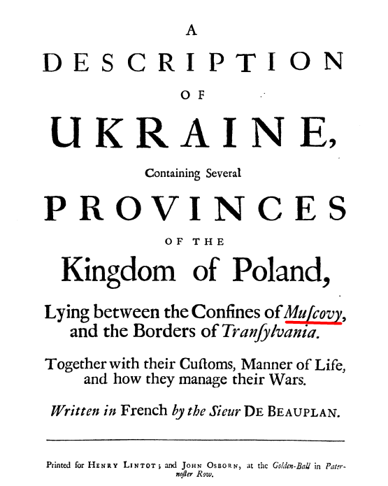
Original book title in French: