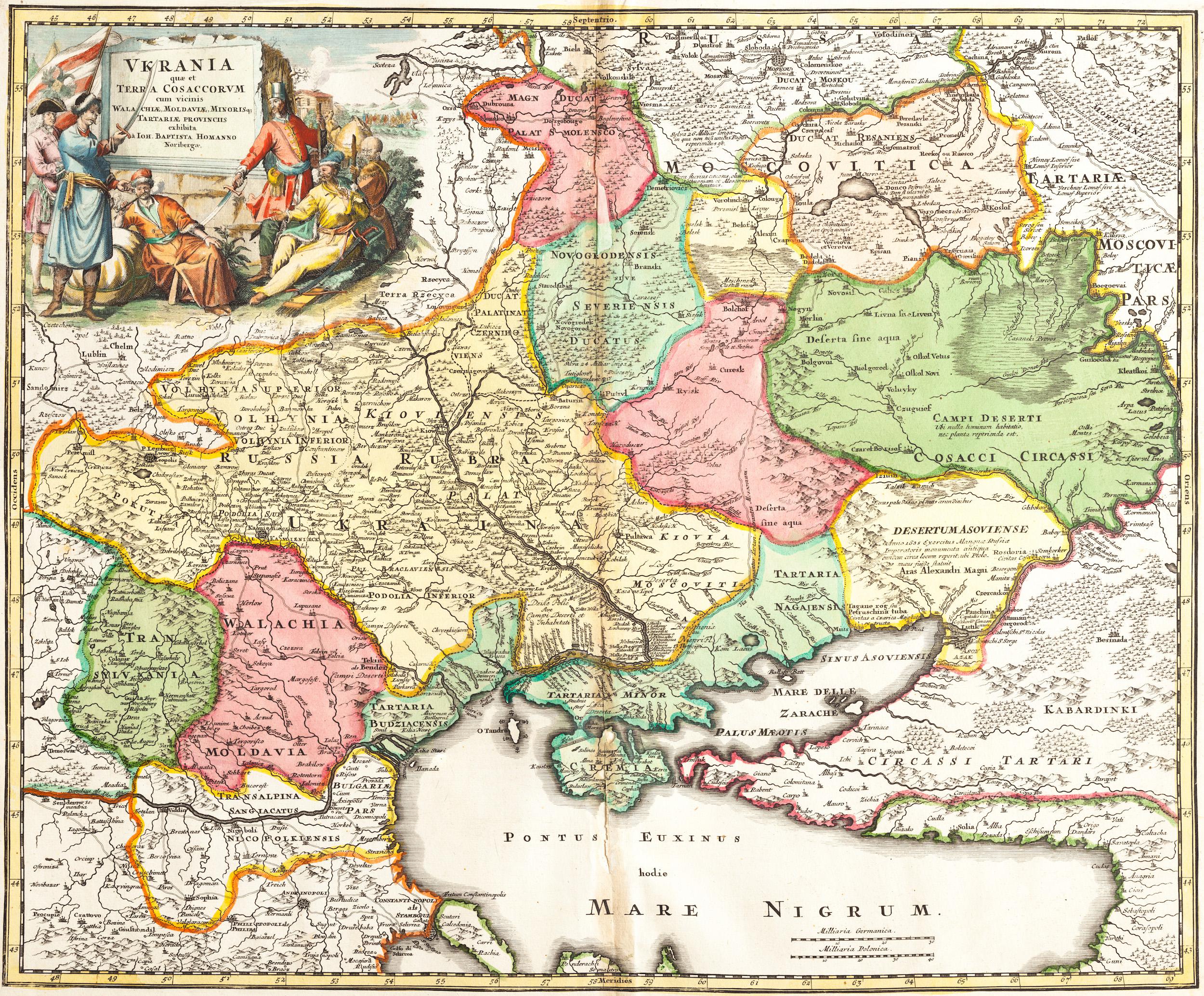
The map was made by a famous German geographer and cartographer Johann Baptist Homann. The map is valuable not just because it can serve as proof of Ukraine’s existence to blind Putin who keeps insisting that there was no such realm before ‘Lenin created it”. (His blunder with the French map of 1674 was discussed earlier). But the current map is also a revelation about the realm that names itself ‘Russia”. As can be seen, there are names such as ‘Moscovy’ and ‘Tartary’ to the north of Ukraine which confirm the earlier statement on this site that before his capture of Kyiv in 1721, Peter I was the tsar of Moscovy only.
The full title of the map is “Ukraine or the Cossack’s Land with neighboring Wallachia, Moldavia, and Little Tartary”.
[article continues below]

Note the names ‘Moscovitica‘ and ‘Tartaria‘ underlined in the map below.

Ukraine realm stretches to the Don River including the northern shore of the Azov Sea and Crimea.
As can be seen below, Ukraine and Red Rus(sia) were part of the same realm in 1720.

While Moscovia and Tartaria were distinctly different areas.

The word ‘Russia’ on top of the map above Moscovia shows the extent of the former Kyiv Rus which included the Novgorod Republic created by Kyiv rulers at the times when Moscow did not exist yet. To put it in simple terms, there was only one Rus – the Kyiv one, of which Moscovy was just a province (and the most backward one by the way).
As a popular comment under a Yahoo article stated: “Kyiv Rus predates the formation of the Russian state and current surrounding countries like Belarus, Estonia, and Russia have long attributed Kyiv as their cultural origin. Technically, Russia should belong to the Ukraine. I suggest Putin should give Russia back”.
‘Ukraine’ and ‘Muscovy’ names in a 1650 book title by French engineer Beauplan >
< Stark Difference between Ukrainians and Muscovites in 1654 observed by Syrian Chronicler
For more details and insights read the “Gardariki, Ukraine” e-book.